12-Digit Watershed Map
Lilly Center for Lakes & Streams
278 Acres
62 Feet
27 Feet
35776 Acres
Tippecanoe River from East
To Lake Tippecanoe
Public: 1 mi S. of N Webster on SR 13, 2 mi W on Armstrong Rd (for Grassy Creek, Tippecanoe, James, Oswego lakes)
Boat, Fish, Ski
Clay, Gravel, Muck, Sand
Bluegill, Redear, Catfish, Black Crappie, Largemouth Bass, Northern Pike, Yellow Perch
$343,875,400 – Tippecanoe Chain
None
Sensitive Population Advisory:
Bullhead Species and Rock Bass
All Sizes: 1 meal per week
Longear Sunfish
All Sizes: Unrestricted Consumption
Largemouth Bass and Smallmouth Bass
All Sizes: 1 meal per month
Northern Pike
All Sizes: DO NOT EAT
For the most up to date information, see the Indiana Department of Health’s website HERE.
Maps
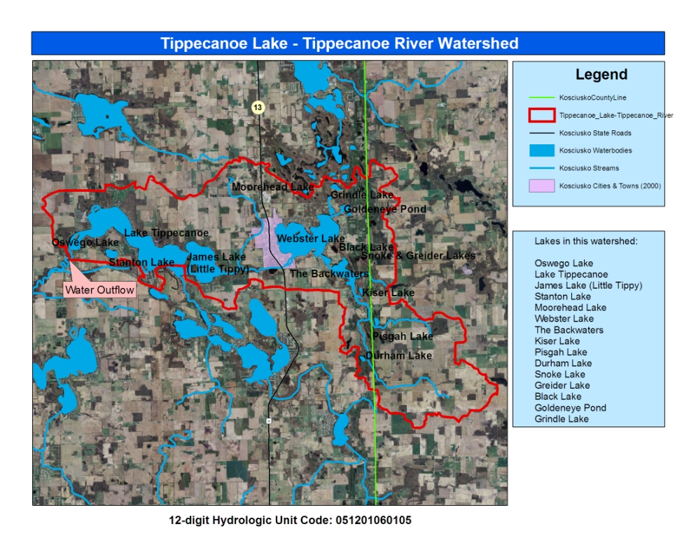
12-Digit Watershed Map
Lilly Center for Lakes & Streams
See the boundaries of Lake Tippecanoe’s watershed.
Original Research from the Lilly Center
2025 Beneath the Surface
Lilly Center for Lakes & Streams
Beneath the Surface will equip you with information that will give your family, organization or agency the ability to care for James Lake.
2024 Beneath the Surface
Lilly Center for Lakes & Streams
Beneath the Surface will equip you with information that will give your family, organization or agency the ability to care for James Lake.
2023 Beneath the Surface
Lilly Center for Lakes & Streams
Beneath the Surface will equip you with information that will give your family, organization or agency the ability to care for James Lake.
2021 Beneath the Surface
Lilly Center for Lakes & Streams
Beneath the Surface will equip you with information that will give your family, organization or agency the ability to care for James Lake.
2021 Your Lake, Your Story
Lilly Center for Lakes & Streams
Your Lake, Your Story tells the story of seven lakes (including the Tippecanoe chain) from the perspective of 15 families that are much like yours. After reading these books, you’ll know fascinating trivia and have home-grown recipes. Woven throughout, you’ll find original Lilly Center research about the lakes’ health.
2017 Your Lake, Your Story
Lilly Center for Lakes & Streams
Your Lake, Your Story combines scientific data with personal anecdotes to tell the story of your lake.
2015 Beneath the Surface
Lilly Center for Lakes & Streams
This is the original Beneath the Surface report, published in 2015. Learn about your lake’s health and compare it to other lakes in the county.
2013 Lake Economic Impact Study: Property Value Report
Lilly Center for Lakes & Streams
When combined with additional property taxes generated due to lake presence, the total economic impact of Kosciusko County lakes is more than $313,383,000 annually.
2014 Blue-Green Algae Study Final Report & Appendix
Lilly Center for Lakes & Streams
This paper synthesizes three years of blue-green algae research (2010-13) conducted by the Lilly Center. We have continued to study the algae and its toxin in-depth.

Need more lake research?
Additional studies and fact sheets are just one click away. Learn about boating, zebra mussels, blue-green algae and more!